project background 1 - science
Q. What on Earth is the attraction of working in such remote and rugged areas!?
A. Well, these areas are rugged and remote, and we like that! Plus, they offer a window into the operations of an active mountain belt, one that we can exploit using a range of diverse techniques.
page 1 - science page 2 - origin and organization page 3 - field work
Compared to the rocks underlying the ocean basins, the continents are complex and their origin remains enigmatic. How the continental lithosphere came to be formed, how continents are assembled, and how they are deformed and reworked are just some of the questions that are currently under investigation by geologists. In the United States, the Continental Dynamics Program of the National Science Foundation provides support for many of these studies, which frequently involve large teams of scientists from around the world.
The Himalaya and Tibet are an excellent place to examine questions about the deformation of crust and mantle lithosphere during continental collision. The Himalayan orogen and the elevated Tibetan Plateau are products of the collision between the Indian and Asian plates, which started some 60 million years ago, and is still continuing. Before collision, Tibet itself was gradually assembled from a series of continental fragments. What makes the Himalaya-Tibet system interesting is that it is young and still active, so that it easier to tease out the role of various mountain-building processes, and in some cases, observe them directly.
In the Himalaya and Tibet, there are a number of issues that have intrigued geologists for over the past decade, and several of these issues are particularly interesting to us. Because they form the intellectual backdrop for our work, it's worth spending a few moments reviewing them.
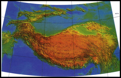
Digital-elevation image of Tibet. Most of the Plateau is fairly flat, but note the incision in the southeast, and also how the rivers help define the eastern syntaxial bend in the Himalaya. After Fielding et al. (1994).
How strong are the rocks in Tibet?
One striking and engimatic feature of Tibet is the height and overall flatness of the plateau. The crust in Tibet is thick, and it was suggested some time ago that the Tibetan lower crust might be weak, likely to flow ,and therefore not capable of supporting large topography. More recent geodynamic computer models support this notion and do well at predicting some of the features of the Plateau, like its steep but undeformed eastern margin, which seems "inflated" from below and the side. Finally, the INDEPTH project obtained geophysical data that some have interpreted as direct evidence for partially molten and thus weak material in southern Tibet.
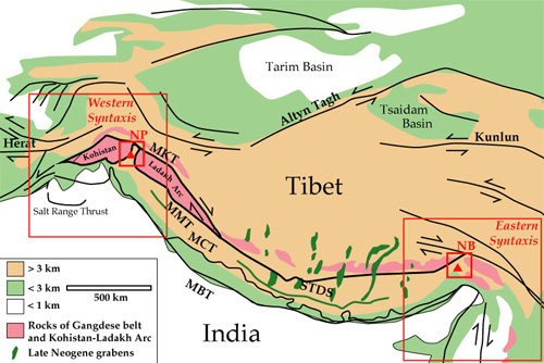
Elevations and tectonics of the Himalaya and Tibet, showing the location of the two Himalayan syntaxes and the Nanga Parbat (NP) and Namche Barwa (NB) massifs. After Harrison et al. (1992).
What happens at the ends of a mountain belt?
The structures and trends of the Himalaya change sharply at both ends of the range, defining bends called "syntaxes." We see this as the expression of a fundamental geodynamic feature, an "indentor corner," that develops along the edges of two colliding plates near the zone of active collision. It is generally accepted that everywhere along the Himalayan arc the Indian "indentor" collides with Asian continental lithosphere, stacking up and deforming the northern edge of India and, in a manner still under hot debate, elevating the Tibetan Plateau. Further, it is possible that the lower mantle part of the impinging Indian lithosphere detaches from the crustal portion, sinking away and leaving the crustal part behind. However messy as all this sounds, the collision is even more complex at the edges of the Indian plate, where material has the option of not only stacking up, but flowing laterally away to the west and east. This lateral motion is evident in the topographic grain of the mountain belt, in the alignment of rivers in southeast Asia, and in results from studies using the Global Positioning System, which show motion around and away from the eastern syntaxis.
How does mountain building influence erosion?
What goes up comes down, so it's not surprising that the growth of mountains leads to vigorous erosion as the mountains develop steep slopes and intercept rainfall. But tectonic processes can control surface evolution in other ways. Of particular interest to us, the Himalayan corners are home to a special feature: big rivers that slice completely across the range, cutting deep gorges as they head to the foothills. The Indus to the west and the Tsang-Po to the east flow along the Himalaya, unable to escape Tibet until they reach the corners, where they take sharp turns to the south. It is not an easy thing and not obvious how a river can cut across a growing range of the size of the Hiamalya. One option is that the river is "antecedent," meaning that it pre-dated the growth of the topography. However, a number of geologists have now come to believe that headward (upstream) cutting, enhanced and focused by the shape of the syntaxes, has led to the fairly recent capture and diversion of Tsang Po and possibly the Indus within the past several million years. This adds yet one more wrinkle to the corner story: erosion is extremely effective and robust here.
Can erosion in turn influence mountain building?
Over the past 20 years, geologists have come to realize that erosion can modulate temperatures in the crust so that on a regional scale erosion can control the distributions of metamorphic rocks (see sidebar). In addition, models show that erosion can divert the flow of material through a growing mountain belt. We believe that under some circumstance such as those that apply to the interiors of indentor corners, erosion can assume an even more important role, perturbing the local temperature field and crustal strength to the point that a self-sustaining zone of failure associated with high-grade metamorphism can develop over scales of only 20-30 kilometers. This "tectonic aneurysm" model invokes deep erosion caused by big rivers to localize crustal failure and create a high-temperature anomaly that can lead to metamorphism and partial melting. Although difficult to prove, such a feature would likely be characterized by feedbacks between the tectonic processes leading to deformation, rock uplift, and metamorphic effects, and the surface processes responsible for erosion and clearing material out of the area. Developed to explain the evidence we collected at Nanga Parbat in the western Himalaya, we are now attempting to test this model using observations made at Namche Barwa, in southeastern Tibet.
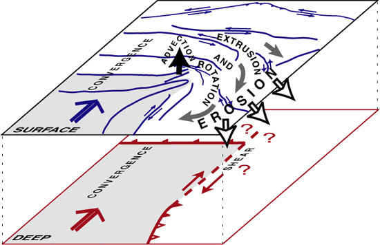
Cartoon showing possible material flux through the eastern Himalayan indentor corner, including decoupling between upper and lower lithosphere, and short-circuit removal of mass by erosion.
How will the indentor-corners project address these issues?
Most generally, we are trying to track the fate and flow of material through the interior of the eastern Himalayan syntaxis. The measurements involved in tracking this flow bear on all the issues mentioned above. At the broadest scale, we want to examine the hypothesis that the lower Tibetan crust is weak, and see how the weak zone is resolved at the edges of the plateau. At both local and regional scales, we want to document what the role of erosion is in moving mass through the system, and more locally, we are attempting to test the idea that Namche Barwa and Gyala Peri are "tectonic aneurysms" that reflect feedbacks between deep and surface processes.
To achieve our goals, we will be making and then integrating measurements based in the disciplines of structural geology, geochronology and thermochronology, array and earthquake seismology, geodesy, geodynamical modeling, petrology, geochemistry, and geomorphology. We've put together an overview of our plans and techniques that you might find helpful.
page 1 - science page 2 - origin and organization page 3 - field work